The Walker’s Haute Route – a complete guide to hiking from Chamonix to Zermatt
- lottieinthewild
- Aug 16, 2024
- 14 min read
Updated: Sep 15, 2024
Hiking the Walker’s Haute Route has been on my ever growing list of hikes and destinations for years. After another trip fell through, I decided it was finally time to get organised and this was the year! I’ll be totally honest, I didn’t train a whole lot for this hike but I was uncharacteristically prepped in the planning area which is what I’m going to share with you below!
This wasn’t an easy hike, the days are long and the ascents are steep but it’s incredibly well signposted and marked along the way that navigation at least is pretty much covered! But there’s a reason it’s one of the world’s best hikes and you don’t want to go in unprepared. It was tough in places, but some of the most rewarding 13 days I’ve spent in the mountains.
Just as a little disclaimer – I’ve popped this guide together to the best of my knowledge from things I learnt when I hiked The Haute Route in July 2024.
More from The Haute Route
my day to day guide (coming soon)

What is The Walker’s Haute Route?
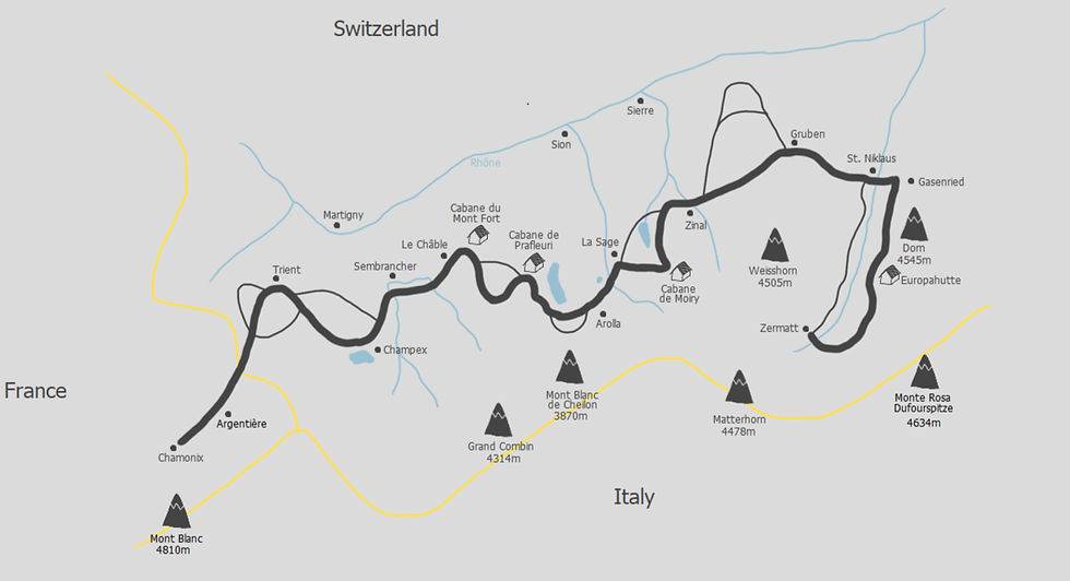
The walker’s haute route, first off should not be considered as a walk as it’s most definitely a hike and named to differentiate it from its winter alpine variant. It’s been named one of The World’s 10 Best Hikes and winds its way from the base of the Mont Blanc Massif in Chamonix, France through the Swiss Alps to Zermatt, Switzerland and the Matterhorn which soars magnificently above.
The Alps is crisscrossed with a network of trails and as such there are many variations to the route, offering shortcuts and bad weather detours but the classic route is;
Difficulty: medium-hard
Distance: 213km / 132mi
Duration: 10-15 days
Highest point: 2,987m / 9,800ft
Mountain passes: 11
Total elevation gain: 14,000m / 46,000ft
Average day: 10-15km / 6-9mi over 6-8hrs with an average elevation of 1,400m / 4,600ft
By using alternative routes you have the option to take in other passes, stay at different huts and either increase or decrease your distance and elevation. This could be as bad weather alt. routes or just personal preference, there’s no right or wrong!
When to hike the Haute Route
In a nutshell, early July – mid September. The biggest factor here is snow and avalanche risk. There are several high passes above 2900m and large areas of remote hiking where heavy snow could create some issues. In a ‘normal’ year, it’s probably not a good idea to go before the beginning of July but saying that, it is the Alps and a heavy dumping of snow could come as late as August.
I started the route on July 6th and the weather was fantastic with only 2 days of rain. The only concerns of snow were between Cabane du Mont Fort and Cabane de Prafleuri where the trail crosses The Grand Desert glacier and is very remote. At Mont Fort we were told that no-one had made the crossing for at least a week due to the snow which left it a little ambiguous because if no-one was trying, how did anyone really know what it was like? I teamed up with a few other hikers at Mont Fort and decided to attempt the crossing as a group of 6 (safety in numbers and all that!) and were successful. The route was completely snow covered but not dangerous although micro-spikes were incredibly helpful.
Side note: The stewards of the mountain huts are very knowledgeable in regards of snow levels and the ease of crossings and if you have any concerns it’s always advisable to ring ahead to he next hut. They will know the weather conditions at the hut and whether any other hikers have made the crossing in recent days. You should note, they will always err on the side of caution and never advise you make a crossing if there is any potential risk, and this decision will lie with you alone.
During the high summer period of July and August the trails will be at their busiest and the temperatures will be at their highest, reaching 30 degrees even above 2500m. September often brings clear weather but by the end of the month a lot of the huts will begin to close as the season draws to an end. October can bring the beginnings of sustained wet weather and snow higher up making some areas difficult or impassable.
A couple of apps which I found useful are;
MeteoSwiss - for the weather, although remember that in the mountains the weather is so changeable it’s not always reliable as a daily forecast!
SwissTopo – a fantastic app of Swiss trails where you can toggle the snow depth as a map layer which I found very useful!
Tip: Get chatting to other hikers! More often than not, they will have the same thoughts and concerns when it comes to snow and talking it through can be really insightful. They may have more experience or just be a good source of information, and don’t forget, it works both ways and you may know something they don’t!
How long does it take?
The standard route, sticking to the guide is between 12-14 days. It can be condensed into a shorter time or stretched out for a more leisurely pace, it really depends on what you want to get out of the route (and the weather!). I did the route in 13 days by having one very short day to spend at a lake and then extending a day at the end and take in the Europahutte. I had a couple of very long days which were difficult but overall 13 days was completely doable and a very steady pace!
Switzerland can be expensive, so extending your trip may incur extra costs which is something to take into consideration!
Before I left, I made a spreadsheet of the route, detailing each day (as described in the Cicerone guidebook) and possible places to stay at each stop. I wanted a mix of camping, Mountain Huts and B&B’s and this made it a lot easier to cost it out and have all the info in one place. On some sections, accommodation is limited where you’ll have very little choice but to stay there (hello, Gruben!) so by camping in some areas, I saved money and used it towards the pricier places in remote areas.

Can you hike it without a guide, or as a solo person?
The short answer: absolutely, 100%, yes!
When researching this trip, I was overwhelmed with the number of guided tours you could take and it made me a little nervous about how safe and manageable it actually was to hike unsupported. However, not at any point on this trip did I feel unsafe or feel that I wasn’t able to navigate the terrain.
A guide for hiking the Haute Route in summer isn’t necessary. The Alps cater so well for hikers that the entire route was very well signposted with yellow trail signs, as well as yellow diamonds and red/white striped waymarkers painted onto boulders and trees. Plus, with the guidebook and .gpx files for your phone it’s really simple! There’s also phone service along most of the trail and lots of other hikers about!
The staff who work at the mountain huts, or anywhere I stayed for that matter were incredibly friendly and helpful. I felt safe everywhere I stayed, including campsites where it’s so easy to get chatting to other hikers and swap knowledge and stories! As the trail went on, I found I was bumping into the same people every day and in the end we formed some really great friendships and ended up eating dinner or sharing a beer most nights. You really meet the most wonderful people on these trails and it’s one of the true highlights.
Where to fly to & getting to and from the start/finish
Most people fly to Geneva as it’s the closet airport, but Zurich is also a possibility although the travel time will be a lot longer.
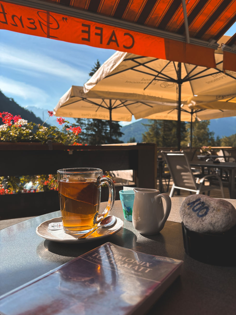
From Geneva, you can take any number of buses to Chamonix which takes around 1h30. They all leave from just outside the terminal doors and drop you off in Chamonix central. Some will even offer a door-to-door service for a premium fare.
I booked my bus before leaving the UK, (it was about £20) but right outside baggage claim, there’s a helpdesk where you can book the buses on arrival. The staff are so helpful, and all speak several languages. I ended up needing to re-book a different bus after my bag got lost and it was a very easy process.
From Zermatt, you can take the train back to either Geneva or Zurich airport.
Which routes to take
So the Haute Route isn’t just one route, but several trails all interlinked. This basically means you can decide to change the distance or elevation you want to take on a day, pass through certain villages and col’s and see certain sights.
Some routes are better as bad weather alternatives where heading over a col in poor visibility might not be a good idea, some routes are used as diversions for trail closures and some might just pass by something you really want to see!
I used the Cicerone guidebook for the basis of my route planning before I left which gave me a pretty good idea, and the SwissTopo app while I was hiking. The guidebooks will give you the recommended route, plus an alternative, but like all things, nothing in the mountains is ever certain and route closures can happen. The SwissTopo app has a ‘route closure’ feature which is incredibly helpful and allows you to plan an alternative should this happen. In some cases, there is no alternative and you may have to get public transport to the next valley.
In this case, the SBB app (for Swiss public transport) is a gem. I used it several times and you can even book tickets through the app to save time. It shows buses and trains, and also if you can take bicycles on board!
Is it possible to camp?
Yes! It’s possible to camp along the way and I stayed at 4 campsites, and one night wild camping. Not every valley has a campsite, and some days are mountain huts only due to the location (unless you wanted to wild camp those!) but the terrain is steep and this isn’t always possible or recommended.
The four campsites I stayed were great and all offered different levels of service. Find them below;
Le Peuty (just before Trient) – this is a community campsite which is basically a field in a tiny hamlet. There’s a small unisex toilet block and hot showers for a small fee (between 4-7pm only). There’s also a large covered area with a BBQ. It’s first come first serve, but basically there’s room for everyone and people will squeeze in! This section has both Haute Route hikers and TMB hikers so it gets busy here! There’s a small refuge which offers a half board service, even for campers so if you want food there book it in as early as possible (probably by 4pm for guaranteed food). There are no shops here or in Trient. website: Refuge le Peuty
Champex-Lac; Campsite les Rocailles. A stones throw from the village which has shops and restaurants. There are no reservations taken here, just arrive as early as you can to find room. There are three terraces for camping and I had no problems finding a spot. They have a tiny shop, shower block, launderette, washing up area for kitchen dishes and wifi. The price is CHF18.40 plus tourist tax of CHF1.60 (as of 2024). Website: www.champex-camping.ch
Arolla; camping Arolla. There are no reservations taken here either but I didn’t have any trouble finding room. This campsite is quite large and has separate terraces for campervans and tents. They have a small shop (you can even order breakfast for the next day from a local bakery!), a great shower block and a BBQ area with covered benches. They also have several dedicated recycling bins and the place is immaculate. There is a pizza restaurant very close but the walk to Arolla is a steep uphill about 20mins. The price is about CHF18 for a small tent and 1 adult (as of 2024). Website: www.camping-arolla.ch
Zinal; Relais de la Tzoudana. About 1km outside of Zinal, this site can be booked online ahead of time but payment will be taken on site (cash or card). It’s a great site with a bar/restaurant, three crystal clear pools and a rabbit run! They offer a dinner package for campers, three courses for CHF28 which was fantastic and beat any of the prices in Zinal. The showers are good and hot but there is only 1 each for men and women. This wasn’t an issue at all, but worth noting. Prices were about CHF15 for a small tent and 1 adult (as of 2024). Website: tzoucdana.ch
How do I book the huts, and are they nice?
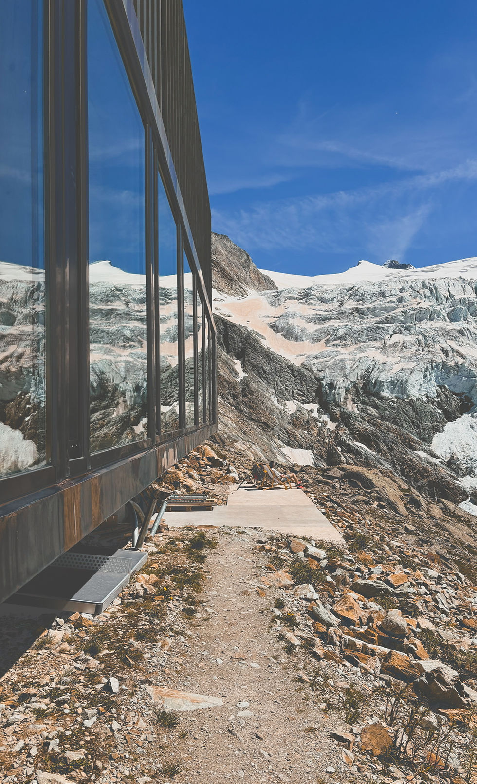
The huts are incredible. Each one has its own charm and I loved them all. The staff are friendly and knowledgeable and the food is just what you need after a long days trekking. I would always recommend going half-board because it saves you carrying the extra weight of food and sets you up for the next day. Most of them will offer a packed lunch service too for an extra fee. This can be great if your route that day doesn’t take you through a village (think Mont Fort > Prafleuri and Prafleuri > Arolla).
The huts can be expensive, and some more so than others, so this is worth a little research. There are also huts along many of the different trails which all make up the Haute Route so this may become part of your trail planning if there’s a certain hut you’d like to stay at or one you’d like to avoid.
Each hut has its own website and I would urge you to book ahead, especially in the high season. While the staff will never ask you to leave if there’s no room or if bad weather comes in (this goes against hut etiquette) it’s better to have a reservation just in case.
Reservations can be made online but payment will be taken when you’re there. Most accept card but take cash just in case.
Side note: sometimes plans change (the weather!) or you just like the look of a hut while walking past and the staff will always try and find room if you want to stay there and haven’t booked. It’s not a hard and fast rule to make a reservation but if you know you’re heading there, I would book.
There are a few huts and websites listed below;
Refuge du Col de Balme (not to be confused with refuge de la Balme)
CHF58 half board inc. tax
find the website here
Cabane du Mont Fort
CHF130 half board inc. tax
find the website here
Cabane de Louvie
(a cheaper alternative to Mont Fort)
CHF78 half board inc. tax
find the website here
I didn’t stay here but had friends who did and said it was outstanding.
Cabane de Prafleuri
CHF80 half board inc. tax
find the website here
Cabane des Dix
CHF97 half board + tax
find the website here
Cabane de Moiry
CHF105 half board inc. tax
find the website here
Europahutte
CHF85 half board + tax
(email bookings only)
find the website here
What do you eat? And is there always water available?
The great thing about the Haute Route is the level of amenities along the way. Unless you’re planning to wild camp the entire thing, you shouldn’t need to pack anything more than hiking snacks, lunches and water. I didn’t struggle to find food at any point, but a little forward planning on some sections is needed;
In Trient (stage 1 or 2 depending on your first day) there are no shops until you reach Col de la Forclaz the next day. You can eat at Col de Balme in the refuge restaurant, and if you arrive early enough in Le Peuty you can get food at the refuge there but this isn’t guaranteed. I would take dinner and breakfast just in case.
Between Verbier and Arolla (stages 5, 6 & 7) there are no villages or shops. The chances are you’ll be staying at 2 of the 4 mountain huts within these stages (Mont Fort, Louvie, Prafleuri or des Dix) and using the half board services will save you carrying food (just take snacks!)
On all other sections of the route I passed enough shops to resupply on food for either that day or the next few days. It’s a lot easier to plan out when you’re really starting to look at the map and find accommodation options, but I never felt like I didn’t have enough food. All my accommodation (except camping Le Peuty) had either a bar/restaurant on site or were close to a village with shops and restaurants.
On the trail I mainly eat a mixture of fruits, nuts, trail/cereal bars, dry cured meats, cheese, crisps and some emergency sweets for when I need fast sugar. I also like to keep 1-2 packets of noodles at the bottom of my bag for emergencies or just really hungry days!

Water is also very accessible on most areas of the trail, but my one piece of advice on this is to get a water filter, either an integrated bottle or separate. This way you can always refill using steams and there’s plenty to go at!
However, almost every village will have clean running water troughs and you can often find them along the trail as well. There was only one day where I didn’t notice a trough (Gruben – St. Niklaus) but there’s still plenty of natural water sources.
Every accommodation will have safe drinking water, even the campsites, but I had an emergency bottle of water in my bag which I carried for two weeks and didn’t need. I use an integrated filter bottle (Lifestraw) and was able to refill enough throughout the day that I never worried about being dehydrated. The mountain huts will boil enough water for everyone and let it sit overnight to cool before allowing you to refill your bottle. Their water isn’t always filtered or comes straight from the mountain runoff and this is a standard precaution. Do not drink the tap water here unless you have a filter.
Languages
In a nutshell, French and German. From Chamonix to Zinal, French is the main language but once you cross Col de Forcletta and drop into Gruben (stage11), the language changes to German. I was told by a lady in Gasenried that in the larger towns like St. Niklaus and Zermatt people will still speak a little bit of French but in the smaller hamlets and mountain villages, its German only.
Like travelling anywhere, it’s really important to attempt to speak the language rather than defaulting to English. Try to learn a few common phrases and words before you go! My French is passable and my German is atrocious but I can still say please, thankyou, order a large beer and a schnitzel!
Will I need cash?
Yes, personally I would always take a cash reserve. Even today where card is accepted in most places it’s handy to have cash, especially in rural communities where it might be the only method of payment. Some huts are quite remote and while they also accept card, the signal isn't guaranteed. I also found in a few locations, even though I had pre-paid for accommodation the tourist tax was to be paid in cash on arrival. It’s normally a nominal amount of about CHF3.
Other pros of cash; it’s easier to budget and watch your spending. You don’t need to worry about currency conversions or foreign charges.
Other helpful tips
Just a recap on some of the apps I found particularly useful while I was hiking;
SBB – for Swiss bus and rail travel. A great app for all public transport, you can buy tickets to save time, see bus/rail stops on the map near your location and even pre-book room for bikes.
Swiss Topo – fantastic maps with layers such as ‘route closures’ and ‘snow depth’. Trails are highlighted in different colours depending on their grade; yellow – walking paths; red – hiking/mountain trails; blue – alpine trails.
MeteoSwiss – for Swiss weather. Not to be relied upon 100% when in the mountains. Weather in the mountains is completely changeable regardless what the forecast is. Always have appropriate clothing and be prepared.
.gpx files
Below are all the gpx files for the standard Haute Route, plus a couple of alternative routes. While they are as accurate as I could make them based on the paths I took, please note you will still need to be able to read a map, have your own navigation system and not to blindly follow these but use them as a starting off point!
At the time of writing this, the Europaweg was closed between Mittelberg - Mieschboden and Springelboden - Eggenstadel so there are no .gpx files for these sections of the route, just the alternative trails that I took.


Comments